For years now, I have been baffled by why ESRI cannot seem to produce high quality raster tiles in their Map and Image Services via ArcGIS Server. With the latest release of ArcGIS 10.2, I was hoping to see some improvements in this regard, but have failed to find the right solution.
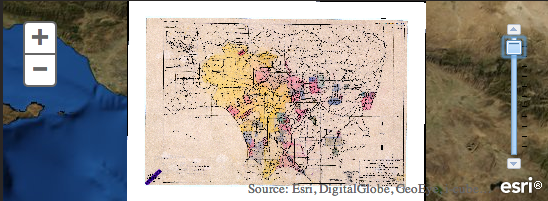
Here is the problem. Publishing a georeferenced raster image as a Tiled Map Service in ArcGIS Server produces the following results:
Our team here at UCLA tried every possible combination of options to produce the best image to no avail. Bilinear, Cubic, etc…
Our next approach was to try to publish this map as an Image Service. This produced promising results: